
By Mary Lyn Fonua
Severe Tropical Cyclone Harold, will coincide with a king tide and a supermoon in Tonga early tomorrow morning. An extreme high tide warning is now in force for all Tonga coastal waters for tomorrow and Friday.
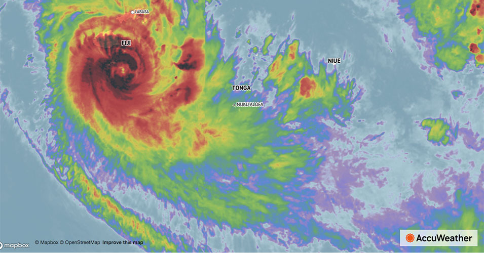
STC Harold (Cat. 4) is bearing down on Tongatapu and 'Eua tonight – and coinciding with 1.87mm king tides for Tonga predicted on Thursday morning
Tonight's full moon is also the biggest and brightest supermoon of 2020 and has a stronger influence on tides.
The highest tides for 2020 were predicted for 9 April at 8:13am, with a height of 1.87mm - not including the weather conditions, (and 1.87mm again at 9:04 am on 10 April).
The actual tide height will be a combination of the prediction and the weather, with huge swells expected to be generated by Severe TC Harold overnight and in the morning.
Advisory
The Fua'amotu Tropical Cyclone Warning Centre advisory no.8 at 3:00pm today (Wednesday 8 April), warned that the extreme high tide warning and a heavy damaging swell warning remains in force for Vava'u, Ha'apai, Tongatapu, 'Eua, Tele-kiTonga and Tele-ki Tokelau coastal waters.
On its current track, Severe TC Harold is expected to lie at about 90km south-west of Nuku'alofa, 100km west south-west of 'Ohunua 'Eua at about 7:00am Thursday morning.
Overnight winds are expected to rapidly increse to storm force winds 50-50-60 knots (100-120 km/hr) with momentary gusts up to 75-95 knots (150-190km/hr) by early tomorrow morning.
Tongatapu and ‘Eua may expect “High seas (6-9 meters). A heavy damaging northwesterly swell (up to 6 meters), poor visibility in area of heavy rain and thunderstorms. Expect flooding in low lying and coastal areas due to heavy rain and damaging swell.”
- A storm force wind warning remains in force for Tongatapu and 'Eua land areas and coastal waters.
- A gale wind warning remains in force for Ha'apai, Tele-ki-Tonga and Tele-ki-Tokelau land areas and coastal waters.
- A strong wind warning remains in force for the Niuas and Vava'u land areas and coastal waters.
- A heavy rain warning and flash flood advisory remains inforce for all of Tonga. A small craft advisory remains in force for all of Tonga coastal waters.
Severe Tropical Cyclone Harold (category 4) was located about 30km west of Kadavu (fiji), 760km west north-west of Nuku'alofa, 790km west north-west of 'Eua, 815km west of Ha'apai at 2:00pm this afternoon.
Severe TC Harold is moving east south-east at the speed of 18 knots (33km/hrs). The maximum winds near the center is about 100 knots (200km/hr) with momentary gusts of up to 140 knots (260km/hrs).
Meanwhile, an active trough of low pressure lies slow moving over Vava'u, Ha'apai, Tongatapu and 'Eua. Associated clouds, occasional rain and strong winds will continue to affect the group today.
For Tongatapu and 'Eua:
North to northeast winds 15-20 knots (30-40km/hr), rising up to 25-30 knots (50-60km/hr) by tonight, then becoming north to northwest winds and rapidly increasing to storm force winds 50-60 knots (100-120 km/hr) with momentary gusts up to 75-95 knots (150-190km/hr) by early tomorrow morning.
Overcast with occasional rain, becoming more frequent by tonight with thunderstorms tomorrow.
High seas (6-9 meters). A heavy damaging northwesterly swell (up to 6 meters). Poor visibility in area of heavy rain and thunderstorms. Expect flooding in low lying and coastal areas due to heavy rain and damaging swell.
For Ha'apai:
East to northeast winds 15-20 knots (30-40km/hr), rising up to 25-30 knots (50-60km/hr) by tonight, then becoming northwest winds and gradually increase to gale force winds 34-47 knots (63-87 km/hr) with momentary gusts up to 55-60 knots (110-120km/hr) by early tomorrow morning.
Overcast with occasional rain, heavy at times with isolated thunderstorms. Very rough seas (4-6 meters).
A heavy damaging northwesterly swell (up to 6 meters). Poor visibility in area of heavy rain and thunderstorms. Expect flooding in low lying and coastal areas due to heavy rain and damaging swell.
For Tele-ki-tonga and Tele-ki-Tokelau:
East to northeast winds 25-30 knots (50-60km/hr).
Becoming southeasterly winds and gradually increase to gale force winds 34-47 knots (63-87 km/hr) with momentary gusts up to 55-60 knots (110-120km/hr) by tonight to early tomorrow morning.
Overcast with occasional rain, heavy at times with isolated thunderstorms. Very rough seas (4-6 meters). A heavy damaging northwesterly swell (up to 6 meters). Poor visibility in area of heavy rain and thunderstorms.
For the Niuas and Vava'u:
North to northwest winds 20-30 knots (40-60km/hr). Overcast with occasional rain, heavy at times with isolated thunderstorms. Rough to very rough seas (up to 4-6 meters) and a moderate northwesterly swell (5 meters) especially Vava'u coastal waters.
Poor visibility in area of heavy rain and thunderstorms. Expect flooding in low lying and coastal areas due to heavy rain and damaging swell.
See also, Severe Tropical Cyclone Harold:
