
Drier than average weather is forecast for Tonga over the next three months (January – March) according to the latest climate update by Tonga Meteorological Services. Tonga's wet season which runs from November until April is also known as the cyclone season.
According to the update released today, the percentage chance of rainfall for the next six months will be lower than average for most areas of Tonga.
![]()

The drier weather is forecast to extend from April to June for most of the country except for Niuafo’ou and Niuatoputapu, who are predicted to enjoy average to above average rainfall.
Meanwhile in December, above average rainfall was recorded for Tongatapu, Ha’apai, and ‘Eua, which was mainly caused by Tropical Cyclone Sarai (see below graph).

Niuafo’ou and Vava’u recorded below average rainfall, while on Niuatoputapu, rainfall was average.

The mean temperature was 26.8oC which was 0.5oC warmer than average. The highest maximum temperature was 32.3oC on 10 December in Nuku’alofa and the lowest minimum temperature was 18.0oC on 12 December in ‘Eua.
Tonga Met reports in the tropical Pacific Ocean, most indicators of the El Niño–Southern Oscillation are neutral.
However, warmer than average sea surface temperatures in the far western tropical Pacific may be contributing to some changes in local weather patterns over the region.
International climate models forecast ENSO-neutral until at least Autumn 2020.
Tonga is currently in its wet season or cyclone season which started on 1 November 2019 up to April 2020.
Tonga Met asked the public to be aware of the current weather situation and stay alert at all times to forecasts and warnings provided.
“Advice should be sought from relevant authorities of sensitive sectors, e.g. Agriculture, Water, Health and the National Emergency Management Office (NEMO) on the best practices to save lives and property and minimize the effects of natural disasters.”
Tonga Ocean Outlook
Tonga Met reports the sea surface temperature is expected to be a little above average in February.
Sea level forecasts are also above average from south of Tonga spreading north, to around average to the northern part of the country for the next three months.
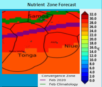
The boundary between warm and cold ocean water, which is rich in nutrients and attacts lots of fish, is predicted to be just north of Tonga.
This zone is forecast to extend further north of Tonga’s EEZ. The green line shows the zones average location for February and the purple line shows the zones forecast for February 2020 (see above graph).
The next extreme highest tide will be on 11 February at a height of 1.85m. The next extreme low tide will be on 9 May 2020.
