
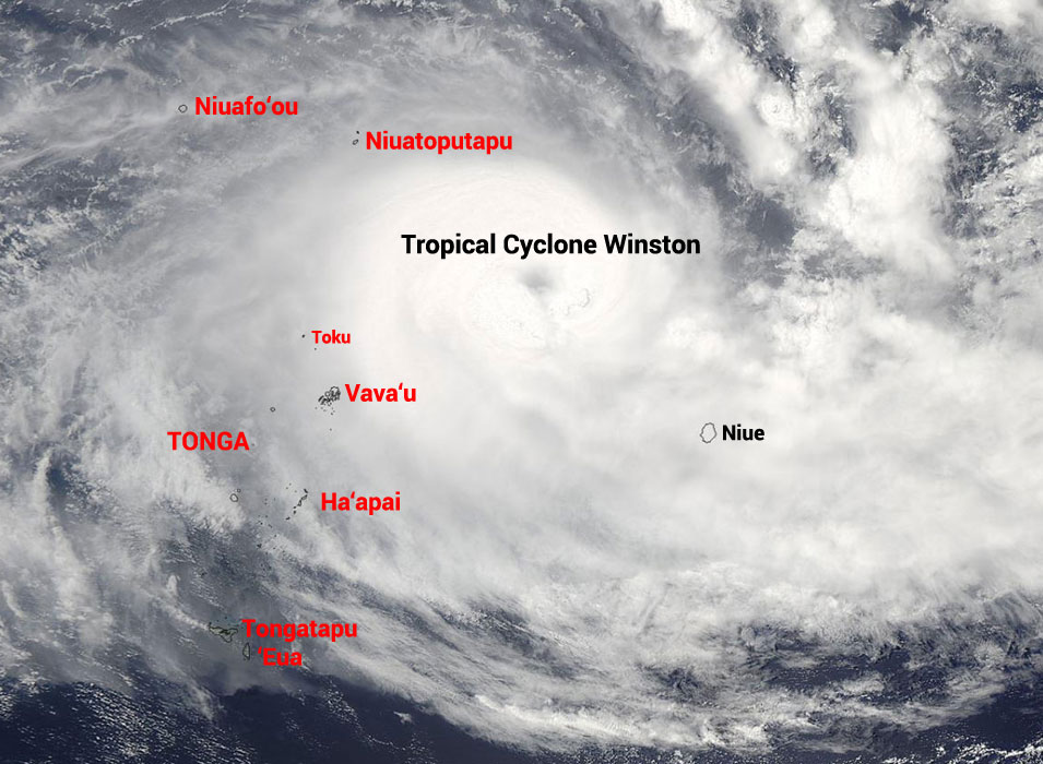
The very large Tropical Cyclone Winston (Cat. 4) currently has hurricane force winds across its 150kms diameter and the intensifying storm might become a high Cat. 4 – or even Cat. 5, sometime before midday Friday, north of Vava’u, warns Tonga Met.
Cyclones of a high Cat. 4 or Cat. 5 force are uncommon in Tonga. “We’ve maybe had five or six over the last 65 years” said Tonga’s Chief Meteorological Officer ‘Ofa Fa’anunu this afternoon. “Cyclone Ian was like this – we can expect widespread destruction.”
The National Emergency Management Committee (NEMC/NEMO) was meeting at 3:00pm today - bringing forward tomorrow’s scheduled meeting after global models predicted an earlier return of the storm.
‘Ofa said that at the moment they forecast the closest approach to land will be 80km north of Vava’u tomorrow morning around 8:00am, Friday 19 February.
“This cyclone’s diameter is very large, 150km, with hurricane force winds for a radius of 70km from the centre. Vava’u is most likely to be on the edge of the hurricane force winds, so we are putting out the word now for storm force winds so people can prepare,” he said.
After slowing down and intensifying in the open sea to the north east of Vava’u today, TC Winston remains highly unpredictable.
“Global models are showing different tracks and I’m worried that it might hit Vava‘u directly,” he said.
The cyclone is looking for its new direction and 'Ofa said they would not know until tonight what the dominant steering wind direction would be.
“It was tracking northeast but because the steering wind dropped to zero there is now nothing steering the cyclone. It can’t go directly south because of the high pressure there, so it’s travelling along a high pressure ridge, and is likely to start moving south east tomorrow, so we are not out of the woods on Tongatapu yet.”
Tonga's latest forecast is:
Tropical Cyclone Advisory #21 for Tonga on Tropical Cyclone Winston issued from the Fua'amotu Tropical Cyclone Warning Centre at 4:00pm Thursday 18 February 2016.
Tropical Cyclone warning
- A storm warning remain in force for Vava'u.
- A gale warning remain in force for Niuatoputapu and Ha’apai.
- A gale alert remain in force for Niuafo'ou, Tongatapu and 'Eua.
- A strong wind warnings remain in force for Niuafo'ou,Ha’api,Tongatapu and 'Eua.
- A heavy damaging swell warning remains in force for all Tonga coastal waters.
Situation:
Severe Tropical Cyclone Winston category 4 was located near 17.1south and 171.0 west or about 325km east-southeast of Niuatoputapu or 360km east-northeast of Neiafu at 03:00pm this afternoon. The cyclone is slowly moving west at 9km/hr (5knots). On its current track, the cyclone is expected to lie about 240km northeast of Neiafu or 210km southeast of Niuatoputapu at 7:00am tomorrow morning (19/02/2016).near its centre, the cyclone is estimated to have an average winds speed of 165km/hr(90knots) with momentary gusts of 230km/hr (125knots).
Forecast:
For Vava'u:
Expect damaging gale force winds 45-55km/hr( 35-45 knots) in the next 15-18hrs increasing to storm force winds 95-110km/hr (50-60 knots) from mid-day tomorrow cloudy to overcast with periods of rain developing tomorrow, possibly heavy at times with squally thunderstorms. Expect very rough to high seas in the next 15-18hrs, increasing to high to very high seas from mid-day tomorrow with a heavy damaging east to southeast swell.
For Ha’apai:
East to southeast winds 45-55km/hr(25-30kts),increasing to damaging gale force winds 45-55km/hr(40-45knots) in the next 18-24.mostly cloudy with occasional showers at times. Very rough to high seas developing tomorrow morning with a heavy damaging east to southeast swell.
For Niuatoputapu:
West to southwest winds 45-55km/hr(25-30knots) and increasing to damaging gale force winds 75-85km/h (40-45knots) in the next 18-24hrs. Mostly cloudy with occasional showers developing to rain, and possibly heavy at times. Very rough to high seas developing tomorrow with a heavy damaging east to southeast swell.
For Tongatapu, 'Eua:
East to southeast winds 45-55km/hr(25-30kts),increasing to damaging gale force winds 65-85km/h (35-40knots) in the next 24-30hrs.mostly cloudy with possible scattered showers at times. Rough seas with a heavy damaging east to southeast swell.
For Niuafo'ou:
West to southwest winds 45-55km/hr (25-30kts),increasing to damaging gale force winds 65-85km/h (35-40knots) in the next 24-30hrs. Mostly cloudy with occasional showers at times. Very rough to high seas.a heavy damaging east to southeast swell.
Tide predictions:
High tide : 04:05pm
Low tide : 10:30pm
The mean sea level pressure recorded at Lupepau'u Airport (Vava'u) at 4:00pm was 997.9 millibars and the relative humidity was 88%.
