
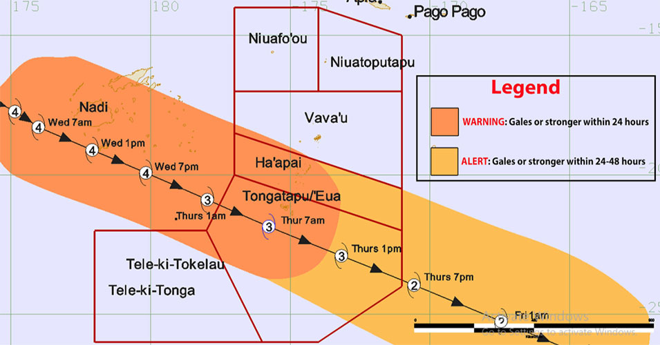
A storm force warning is in force for Tongatapu as severe Tropical Cyclone Harold was located 965km west north west of Nuku'alofa at 08:00am this morning and tracks closer.
The Fua’amotu Tropical Cyclone Warning Centre issued the storm force wind warning for Tongatapu and 'Eua land areas and coastal waters, in its advisory number 6 issued at 9:00am today, Wednesday.
A gale warning remains in force for Ha'apai, Tele-ki-Tonga and Tele-ki-Tokelau land areas and coastal waters.
A strong wind warning remains in force for the Niuas and Vava'u land areas and coastal waters. Heavy rain warning and flash flood advisory remains in force for all of Tonga.
A small craft advisory remains in force for all of Tonga coastal waters.
The heavy damaging swell warning for Tongatapu, 'Eua, Tele-ki-Tonga and Tele-ki-Tokelau coastal waters is now in force for Ha'apai and Vava'u coastal waters.
Situation
At 8:00am, severe Tropical Cyclone Harold (category 4) was located near latitude 18.2 south, longitude 176.1 east or about 150km west south-west of Nadi (Fiji), 1015km west of Pangai, 965km west north-west of Nuku'alofa, 995km West north-west of 'Eua.
It is moving east-southeast at the speed of 19 knots (38km/hrs) with the maximum winds near the center be about 100 knots (200km/hr).
On its current track, severe Tropical Cyclone Harold is expected to lie at about 105km south-west of Nuku’alofa, 100km west south-west of 'Ohonua 'Eua, 270km south south-west of Pangai Ha'apai at about 7:00am tomorrow morning.
Meanwhile, an active trough of low pressure lies slow moving over Vava'u, Ha'apai, Tongatapu and 'Eua.
Associated clouds with occasional rain continues to affect the group for today.
For Tongatapu and ‘Eua:
East to northeast winds 15-20 knots (30-40km/hr), rising up to 25-30 knots (50-60km/hr). Winds becoming north to northwest storm force winds 48-63 knots (88-117 km/hr) by early tomorrow morning.
Overcast with occasional rain, heavy at times with isolated thunderstorms with very rough seas (4-6 meters).
A heavy damaging northwesterly swell (up to 6 meters), poor visibility in area of heavy rain and thunderstorms. Expect flash flood in low-lying areas due to heavy rain.
Ha'apai, Tele-ki-Tonga and Tele-ki-Tokelau:
East to northeast winds 15-20 knots (30-40km/hr), rising up to 25-30 knots (50-60km/hr). Winds becoming north to northwest damaging gale force winds 34-47 knots (63-87 km/hr) by tomorrow morning.
Overcast with occasional rain, heavy at times with isolated thunderstorms with very rough seas (4-6 meters). A heavy damaging northwesterly swell (up to 6 meters).
There will be poor visibility in area of heavy rain and thunderstorms and expect flash flood in low-lying areas due to heavy rain.
For Vava’u:
North to northwest winds 15-20 knots (30-40km/hr), increasing to 25-30 knots (50-60km/hr) this evening.
Overcast with occasional rain, heavy at times with isolated thunderstorms. Rough to very rough seas (4-6 meters), with heavy damaging northwesterly swell (up to 5 meters).
Poor visibility in area of heavy rain and thunderstorms. Expect flash flood in low-lying areas due to heavy rain.
For the Niuas:
North to northwest winds 15-20 knots (30-40km/hr), increasing to 25-30 knots (50-60km/hr) this evening.
Overcast with occasional rain, heavy at times with isolated thunderstorms, with moderate to rough seas (up to 3 meters).
There will be a moderate northerly swell (2-4 meters).
Poor visibility in area of heavy rain and thunderstorms and expect flash flood in low-lying areas due to heavy rain.
