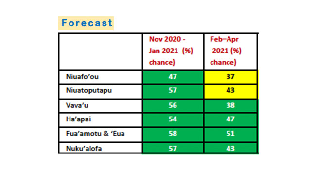
Above average rainfall is forecast across Tonga up to January 2021 (see table above), according to the latest climate update from Tonga Meteorological Service.
Rainfall from February to April 2021, is forecast to be average to above average.
Meanwhile, the current La Nina is forecast to be short-lived as conditions are not as strong as in 2010-12, and is likely to continue at least through February 2021.
La Nina, possibly, increases the chance of receiving above average rainfall during the wet season across Tonga.
Given the current La Nina status, Tonga Met advises the public to be aware of the current climate status, collect water when it rains, and stay alert at all times to forecasts and warnings provided.

October rainfall
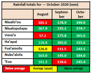
Rainfall recorded for October was above average across Tonga with the highest rainfall recorded on Niuafo’ou.
The mean temperature was 24.9 C which was warmer than average.
The highest maximum temperature recorded was 31.4 C on 18 October in Niuatoputapu and the lowest minimum was 18.3C in ‘Eua on 19 October.
Tonga is currently in its wet season or cyclone season which runs from 1 November 2020 to the end of April 2021.
Traditional knowledge indicating cyclones

Tonga Met is also using traditional knowledge indicators to forecast tropical cyclones.
The indicators for possible cyclones to happen include
- fruit trees unusually bearing plenty of fruits, especially mangoes and breadfruit;
- bees nesting lower near the ground and inside empty coconut shells to hide from cyclones;
- spiders nesting in closed areas where it is safe;
- young shoots of banana leaves bending; and
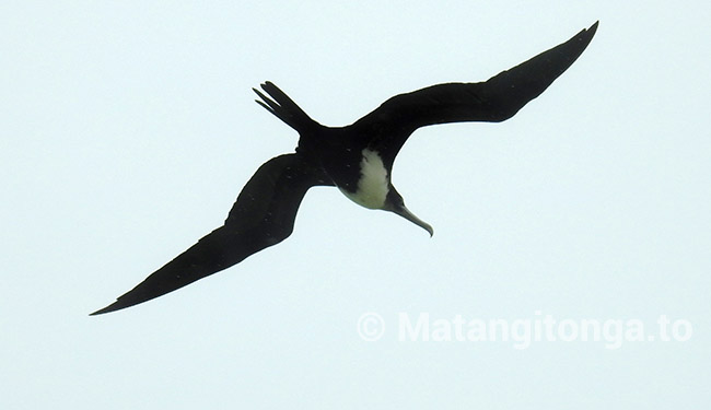
- frigate birds hunting inland when it is not normal for them to do so.
However, none of these indicators are occurring at this stage. Currently fruit trees are hardly bearing fruits, bees are nesting in the open, spiders are also making their web in the open, there are no signs of young banana shoots bending, and no sighting of frigate birds inland.


