
UPDATED FORECAT at 7:00pm, 1 March 2026
Tropical Cyclone Urmil (Cat, 2) passing through the coastal waters of Tele-ki-Tonga and Tele-ki-Tokelau today, is expected to move out of Tonga's maritime boundary by later tonight.
In a 5:00pm forecast (below) Tonga Meteorological Services maintained a Tropical Cyclone warning for southern Tonga and warned that heavy rain and strong to damaging gale force winds could affect some areas.
Forecast and advisories from Tonga Meteorological Services. Issued Time: 5:00pm Sunday 01st March 2026:
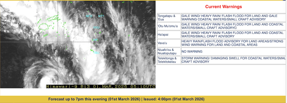
A tropical cyclone warning remains in force For Tongatapu, 'Eua, Tele-Ki-Tonga and Tele-Ki-Tokelau
Warnings:
Warning for land areas:
Gale warning remain in force for Ha'apai, Tongatapu and 'Eua land areas.
Heavy rain warning and flash flood advisory remain in force for Vava'u, Ha'apai, Tongatapu And 'Eua land areas.
Strong wind warning remain in force for Vava'u land areas.
Warning for coastal waters:
Storm warning and heavy damaging swell remain in force for Tele-Ki-Tonga and Tele-Ki-Tokelau coastal waters.
Gale warning remain in force for Ha'apai, Tongatapu and 'Eua coastal waters.
Strong wind warning remain in force for Vava'u coastal waters.
Small craft advisory remain in force for Vava'u, Ha'apai, Tongatapu, 'Eua, Tele-Ki-Tonga and Tele-Ki-Tokelau coastal waters.
SITUATION:
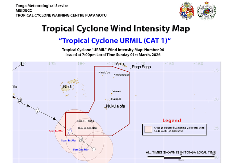
Tropical Cyclone Urmil (category 2) was located near latitude 24.7 south, longitude 178.0 east or 805km west South west of Nuku'alofa, 810km West South West of 'Eua at 3:00pm this afternoon. Tropical Cyclone Urmil (category 2) is moving southeast at the speed of 23 knots (46km/hr). The maximum sustain winds near the center is about 50 knots (100 km/hr) with momentary gust of up to 60-70 knots (120-140km/hr). Associated clouds, heavy rain and strong winds, damaging gale to storm force winds will affect Ha'apai, Tongatapu, 'Eua, Tele-Ki-Tonga and Tele-Ki-Tokelau coastal waters.
For Tele-Ki-Tonga and Tele-Ki-Tokelau:
North to northwest winds 35-45 knots (70-90km/hr) with momentary gust up to 55-65 knots (110-130km/hr) at times today. Mostly cloudy and overcast with heavy rain and isolated thunderstorm.
High to very high seas (up to 7-10 metres). A heavy damaging Northwesterly swell (up to 4-6 metres). Poor visibilities due to heavy rain.
For Ha'apai, Tongatapu and 'Eua:
North to northwest winds 25-35 knots (50-70km/hr) with momentary gust up to 40-45 knots (80-90km/hr) at times.
Mostly cloudy with occasional rain, heavy at times with isolated thunderstorms.
Rough to very rough seas (up to 4-6 metres). Poor visibilities due to heavy rain.
Possible flash flood in low lying areas due to heavy rain.
For Vava'u:
North to Northwest winds 15-20 knots (30-50km/hr) rising up to 25-30 knots (50-60km/hr).;
Cloudy with occasional rain, heavy at times with isolated thunderstorm.
Moderate seas (up to 2.5 metres).
Possible flash flood in low lying areas due to heavy rain.
For the Niuas:
north to northeast winds 10-15 knots (30-40km/hr) rising up to 20 knots (40km/hr).
Cloudy at times with occasional showers, possibly heavy at times.
Moderate seas (up to 2 metres).
Tide prediction
High tide: 5:50pm
Low tide: 12:15am midnight tonight
The mean sea level pressure recorded at Fua'amotu Airport at 4:00pm was 1003.8 millibars and the relative humidity was 85%.
This next tropical cyclone warnings on Tropical Cyclone Urmil for Tonga will be issued about 7:00pm this evening.
