
Tonga Met updated a Storm Warning at 1:00pm today for the next 24 hour for areas in the north of Tonga.
A slow moving Tropical Disturbance 06F is forecast to deliver gales to the Niuas today, and has the potential to develop into a Tropical Cyclone in the next 48 hours, the Fua'amotu Tropical Cyclone Warning Centre advised at 8:00am today, Thursday.
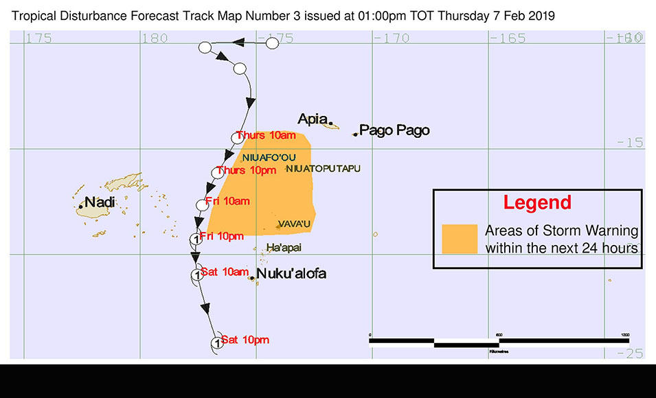
The latest forecast track map brings the system closer to Tonga than previously forecast. The current map forecasts a tropical cyclone developing as the system moves to the west of Vava'u, Ha'apai and Tongatapu on Saturday.
At 10:30am this morning Tonga Met downgraded their Tropical Cyclone Alert for the Niuas, to a gale warning.
A strong wind warning remains in force for Vava'u, Ha'apai, Tongatapu, 'Eua, Tele-ki-Tonga and Tele-ki-Tokelau land areas and coastal waters.
A heavy rain warning and flash flood advisory remains in force for all of Tonga.
TD 06F was located near latitude 11.2 South, longitude 175.7 West or 487km North of Niuafo'ou, 569km North northwest of Niuatoputapu at 01:00am early this morning. This system is slow moving.
Forecasts:
For Vava'u and Ha'apai:
East to northeast winds 15-20 knots (27-37 km/hr), gradually increasing to strong winds 25-30 knots (45-55 km/hr) at times. Cloudy with occasional rain, heavy at times with possible isolated thunderstorms.
Rough seas. A moderate northeasterly swell.
For Tongatapu and 'Eua:
East to northeast winds 15-20 knots (27-37 km/hr), gradually increasing to strong winds 25-30 knots (45-55km/hr) at times. Mostly cloudy with occasional showers, possibly heavy falls with isolated thunderstorms.
Rough seas. A moderate Southeasterly swell.
Tide prediction
High tide: 09:30am
Low tide: 03:25pm
The mean sea level pressure recorded at Fua'amotu Airport at 8:00am was 1007.5 millibars and the relative humidity was 97%.
