Tropical Cyclone Lin moves over Tonga [1]
Sunday, April 5, 2009 - 05:01. Updated on Friday, September 12, 2014 - 13:36.
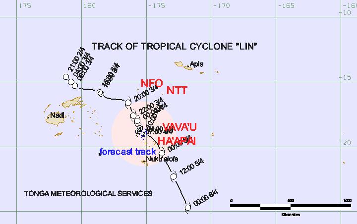
Strong, gusty winds and rain are lashing the capital Nuku'alofa as the centre of Tropical Cyclone Lin moves towards southern Tonga in the early hours of Sunday morning. A storm warning remains in force for Ha'apai, Tongatapu and 'Eua Island groups. On its current track, the cyclone centre is expected to lie about 90km southwest of Ha'apai or about 95km north of Nuku'alofa at 7:00am this morning and about 55km northeast of Tongatapu at 10:00am this morning.
See also latest Tonga Met forecast: Track of Tropical Cyclone "Lin" [2]
Special Weather Bulletin Number 12 issued from NWFC Fua'amotu at 3:00am Sunday 5 April, 2009.
A tropical cyclone warning
A storm warning remains in force for Ha'apai, Tongatapu and 'Eua island groups.
A gale warning remains in force for Vava'u group.
A strong wind warning remains in force for the Niuas.
Tropical cyclone Lin centre was located near 19 decimal 5 south 175 decimal 5 west or about 125km west-northwest of Ha'apai or about 160km north northwest of Tongatapu at 1:00am this morning. The cyclone is intensifying.
Close to its centre, the cyclone is estimated to have average sustained winds of 55 with momentary gusts to 75 knots. Winds expected to increase to 60 knots with momentary gusts to 80 knots in the next 3 to 6 hours.
The cyclone is moving south at about 08 knots and is expected to curve southeast. On this track, the cyclone centre is expected to lie about 90km southwest of Ha'apai or about 95km north of Nuku'alofa at 7:00am this morning and about 55km northeast of Tongatapu at 10:00am this morning.
For Ha'apai, Tongatapu, Eua and nearby smaller islands: expect east to northeast winds increasing to destructive storm force with average speeds of 55 to 60 knots with momentary gusts to 80 knots in the next 6 to 9 hours. Frequent heavy rain and squally thunderstorms. Flooding including sea flooding of low-lying coastal areas. Please be advised that high tide is about 3:30am this morning.
For the Vava'u group:
Damaging gale force winds with average speeds of 35 to 40 knots with momentary gusts to 60 knots easing later today. Frequent heavy rain and squally thunderstorms. Flooding including sea flooding of low-lying coastal areas.
For the Niuas:
Northwest winds 20 to 30 knots with gusts to 40 knots. Periods of rain, heavy at times with squally thunderstorms. Flooding including sea flooding of low-lying coastal areas.
The following information is provided especially for the mariners: expect winds of 55 knots close to centre increasing to 60 knots in the next 3 to 6 hours. Expect winds over 47 knots within 50 nautical miles of centre. Expect winds over 33 knots within 150 nautical miles of centre. High to very high seas. Damaging heavy swells. Poor visibility in heavy rain and squally thunderstorms.
The next special weather bulletin for Tonga will be issued around 6:00am by the National Weather Forecasting Centre at Fua'amotu.
See also:
NWFC Fua'amotu Special Weather Bulletin (English) [3]