
Tongan geologist Taaniela Kula said this evening that a Late Iki Island (Metis Shoal) eruption over the last two days was emitting only steam, heat and gas into the atmosphere. While there may be a hazard within 4-5 kilometers radius of the vent, another hazard may be volcanic fog that can form downwind from the island causing inconvenience in civil aviation and maritime operations.
The Tonga Geological Services Office of the Ministry of Lands and Natural Resources stated that several observations of the event were made between October 13-15.
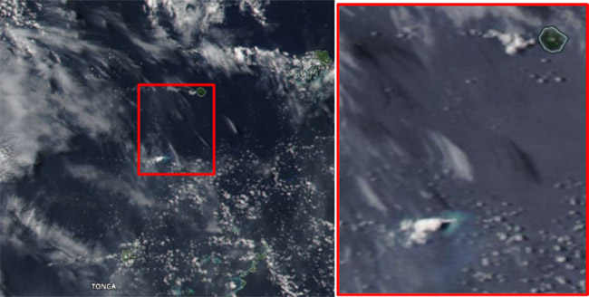
They said that Late Iki Island (Metis Shoal) erupted on Sunday 13 October 2019, and was first reported by MV Ngutulei at 8:00am Monday 14 October 2019. A Volcanic Observatory Notice for Aviation (VONA) at the Tonga Meteorological Services (TMS) and Tonga Geological Services was activated.
“From NASA’s Worldview the source of the eruption was confirmed to be from Late Iki Island. The first flight of Real Tonga Airlines on Tuesday morning 15 October confirmed the height of the fumarolic eruption to about 15,000-17,000ft.”
“During this eruption direct observations were reported:
- 8:00am 14 October, MV Ngutulei saw the eruption south of Late Island (and reported the event to the Coastal Watch at Tonga Met at Fua’amotu).
- 7:32am 15 October, Real Tonga Pilot saw smoke from Late Iki at 13,000 - 14,000 feet.
- 8:25am 15 October, Real Tonga Pilot reported more smoke up to 15,000 -17,000 feet drifting north.
- 1:00pm 15 October, Town Officer of Fotuha’a (38 Nautical Miles (70km) SSE of Late Iki) reported eruption to be visible.
- 3:37pm 15 October, Real Tonga Pilot reported smoke cloud residue at 11,000 -12,000 ft with no further eruption from Late Iki.”
Potential hazards
“The observed eruption was fumarolic as it was only emitting steam, heat and gas into the atmosphere. It may have become explosive as experienced in 1995 creating ballistic hazard within 4-5 km radius from the vent. Another hazard is volcanic fog, known as VOG can form downwind from the island causing inconvenience in civil aviation and maritime [operations].”
Taaniela reported that Late Iki Island is a lava dome that emerges 43m above sea level with a 280m diameter on the tip of a submarine volcano formed during the 1995 eruption. He said that the volcano, located midway between the islands of Kao and Late Islands, about 24 nautical miles (44km) SSW of Late Island and 30 nautical miles (55km) NNE of Kao Island, had erupted several times in the past.
“It produced ephemeral shoal islands before [in] 1781, 1854, 1967, 1979 and subsequently submerged after each eruption. During inactive periods, subsequent reefs and sandy banks with depths of 10 metres or less have been observed in the area. Dacitic tuff cones formed during the eruptions in 1967 and 1979 were soon eroded below sea level. The 1979 eruption released large pumice rafts that were seen between Tonga and Fiji. The 1995 was a strong eruption with ash emission and lava forming the dome shape.”
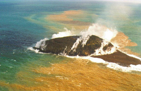
The Tonga Geological Services reported that today Late Iki Island is only a portion of what it was in 1995 when aerial photographs were made (above).
Tracking of this week's eruption in Tonga was made possible through a collaboration of the Tonga Meteorological Services, Tonga Airports Limited, Civil Aviation, NZ Meteorological Services, GNS (Geological & Nuclear Science) New Zealand, Australia Bureau of Meteorological, mariners, and outer island Town Officers.
