
Strong El Nino conditions, peaking in Tonga in recent weeks, have been among the three strongest El Nino events of the past 50-years, suggested by temperatures recorded in the tropical Pacific Ocean.
Tonga's Meteorological Division today stated that the El Nino conditions mean that the rainfall outlook for the next three-months is below average, with a higher chance of a tropical cyclone.
For Tonga, El Nino usually brings cooler night time temperatures, less rainfall and more cyclones than usual.
In December last year, the highest maximum daytime temperature was 33.9° C in Niuafo’ou on December 24, and the lowest night time minimum temperature at 17.1°C on December 10 in Vava’u.
Rainfall
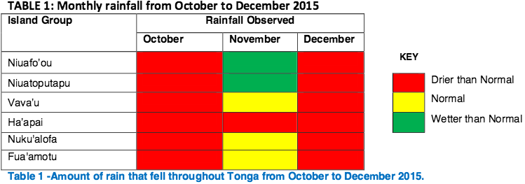
Meanwhile, rainfall received throughout Tonga last month was below average. Dry conditions over the Niuas were eased in November during the passing of Tropical Cyclone Tuni and also rain bands from tropical depression later named TC Ula in December 27-29.
At the same time, rainfall forecast for the next three to six months is for below normal conditions for Tonga, therefore people are advised to collect as much water as possible. This pattern of three months outlook is normal of El Nino years.

With the strong El Nino peaking in the past few weeks according to most climate models, the rainfall outlook for the next three months is below average with higher chance of tropical cyclone occurrence.
Tonga Met advised, especially for smaller islands that do not have ground water, to collect as much water as possible when it rains and use it wisely for drinking purposes only.
"Planners are also encouraged to activate their drought response and tropical cyclone plans and remain alert for the possible continuation of below average rainfall for the next six months.
"Sectors such as Agriculture and Fisheries (Food Security), Health, Water Resource Management and Tourism should take extra measures in public awareness and continue drought operations and tropical cyclone planning and the conservation of rain water." they stated.
Meanwhile, climate models suggest the 2015-16 El Nino will decline during the coming months with the return to El Nino Southern Oscillation neutral most likely during the second quarter of this year.
